Cut Fill Volume Calculation
Cut and fill extraction, sometimes called “excavation and embankment,” means moving earth from one location to another to reach a particular surface or volume. Construction teams use cut and fill maps generated from topographical surveys, often performed by drones, to see where they need to add or remove material. Having accurate cut and fill maps helps construction teams plan earthwork projects, track material inventories, and monitor progress. This is a call to industries like Construction, Mining, Agriculture, Utility and similar ones that in order to complete their projects, need reliable, easy, fast, safe and especially accurate stock pile volume calculations. As you might already know, traditional methods of volume calculations are walking wheel, truckload and bucket count method or the eyeballing method. Unfortunately, all these methods have some common drawbacks and challenges, including inaccurate results. All these challenges might lead to profit lose due to wrong calculations, we will also compare multiple measurements, visualize in realistic 3D detail, and detect changes We are for this solution, please contact us
...more
UAV Imagery Processing
We have gather vast experience in drone survey this survey system can provide more precise survey data with a minimum cost. Processing all the acquired images took only a few hours, generating complete Arial Image of the entire region. These procedures can take a lot less time and cost than traditional survey, yet provide much more detailed spatial information, even in the un-approachable conditions. Conclusively, the new technology of can perform entire tasks efficiently and in completely human-safe conditions. We also provide solution to the clients,already done the image collection job but not able to complete the orthorectification for making a complete aerial image, DSM(digital surface model, classifying point clouds etc. We are very much expert in this field, please contact us.
...more
Topographic Survey
If you are looking for Topographic survey services, you are in the right place. Our company Zodiac Infosolec is the best for these services. The Topographic Survey locates all surface features of a property and depicts all-natural features and elevations. In essence, it is a 3-dimensional map of a 3-dimensional property showing all-natural and man-made features and improvements. Specifically, it shows their location, size, height and any elevation changes. Topographic surveys, also known as contour surveys, may be required as part of real estate transactions, civil engineering design and construction projects, including: • New construction • Remodelling projects to existing structures • Utility design • Road or bridge design or improvements • Grading or drainage projects Contact us and get our services today.
...more
Topographic Mapping
Zodiac Infosolec is well known for its Topographic mapping services in West Bengal, India. These mapping services are used to identify and also to map the contours along with existing features on the earth's surface. This is extremely beneficial for the industries like emery sector, defence sector and a lot more. The services that we provide are used for different types of purposes that include: • As supporting data for a proposed housing development • To inform architects and planners on the development of new builds and extensions • To support a Land Registry Plan submission We use the latest tools and technology for these services and ensure that our customers get accurate results. Contact us and get our services without much thinking.
...more
Scanning and Digitization services
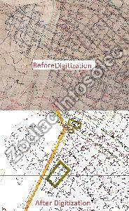
Scanning and Digital Imaging is the conversion of Physical documents and images of any kind, in any format, into their digital equivalents. Reduction in physical space requirements and a much quicker document search and retrieval are just two of the many benefits of digitizing your paperwork. Scanning resolution shall 200/300/400/600 dpi or better as per S.O., raw master image uncompressed and clean master image loss less compression shall be in file format Tiff 6.0 or better. The scanned documents shall be converted into any of the standard file formats such as TIFF/PDF/JPEG/RTF/ODT/PNG/GIF or other standard formats as per the requirement of the Clients. All the pieces of a single map have to be stitched together to generate complete map. The stitched map should be represented in a TIFF/ PDF format or any other standard format as per user requirement. After all rectification / robber sheeting of the scanned map digitization work started for native vector format. We have large size of scanner, plotter and dedicated team that continuously work for our valuable clients We are always ready to serve this type of jobs please contact us to serve you better.
...more
Revenue Plot Marking
Are you looking for Revenue Plot Survey Services in India? You are in the right place. Our company is the best for these services. We have been working in this field for years. We understand the needs and requirements of our customers and ensure that they get the best services from our company. The experts and professionals of our company are trained and skilled and they ensure that customers are served in the best way possible with high accuracy. Hire us and get our services today. Tell us your needs and requirements and we promise to fulfil all your needs on time.
...more
Cadastral Mapping
Zodiac Infosolec has made a huge name in the market as the best Revenue plot Mapping service in West Bengal, India. Revenue Plot Mapping is the process that which lands parcels are made for effective and efficient land management. This mapping service generates the maps that are created from the base maps along with polygons that have details about the property ownership and other such related information. The base map is technically used in this mapping service as the cadastral map that shows individual plots in different divisions. The land paroles are one the fundamental data that has different referenced data. Get the best services from our company today. Contact us to learn more about our company and its services.
...more
Plot / Land Measurement Services
Are you looking for Plot Marking Services in India? Our company Zodiac Infosolec based in West Bengal provides customers with the best Marking Services at an affordable price. We have trained professionals who provide the best possible services to our customers and clients. They have been in this field for years and have gained experience to do such work with perfection. Our company has made a huge name in the market and offer customers with services that they need. We understand that Plot Marking can be important for several reasons and therefore pay attention and care while providing such services. Contact us and get our services in no time.
...more
photogrammetric services
Our company have years of experiences is this this services, Photogrammetry is the science and technology of obtaining reliable information about physical objects and the environment through the process of recording, measuring and interpreting photographic images and patterns of electromagnetic radiant imagery and other phenomena. The photos are taken from different locations and angles to allow for precise calculations that help analysts gather the data they’re looking for. Typically, they use things like photo interpretation and geometric relationships to gather measurements. With the data gathered from photogrammetry, we can create maps and 3D models of real-world scenes. We have dedicated team for this special type of job. Get our services today.
...more
Underground Mine Survey
Underground Mine Survey : as we provide multiple solution under the same roof we provide the best survey solution for Underground Mine also. We provide the right mine survey services to assist the progression of your mining project. Therefore, we understand the needs of the mining community. we successfully completed our job In many mining and mineral extraction industry. As leading mining surveys specialists, we have extensive experience producing detailed surveys, facilitating exploration and mapping mines of all kinds. Our team has mined and quarried a variety of products from surveyed sites. Making use of some of the latest technologies, such as laser scanning, means we can help our clients plan and deliver on their projects by providing them with thorough mine surveys within the time frame set out at the start. Get our services today.
...more
Drone Survey
We have gather vast experience in drone survey this survey system can provide more precise survey data with a minimum cost. Processing all the acquired images took only a few hours, generating complete Arial Image of the entire region. These procedures can take a lot less time and cost than traditional survey, yet provide much more detailed spatial information, even in the un-approachable conditions. Conclusively, the new technology of can perform entire tasks efficiently and in completely human-safe conditions. Therefore contact us and get our services today.
...more
dgps survey
Zodiac Infosolec is the best for DGPS Survey Services in India. This survey is used for the improved location accuracy, in the range of operations of each system, these surveys are constantly correct to the sub-centimetre level. Each DGPS Survey is done using a network of fixed ground-based reference stations to broadcast the difference between the positions indicated by the GPS satellite system and known fixed positions. These stations broadcast the difference between the measured satellite pseudo ranges and actual (internally computed) pseudo ranges, and receiver stations may correct their pseudo ranges by the same amount. We generally use DGPS for staking out a point or determine the coordinates of a boundary corner or setting up base station in Global (UTM/Lat-Long) coordinates system. Therefore contact us and get our services today.
...more
contour mapping services
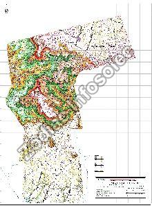
If you are looking for contour Mapping Services, you are in the right place. Our company Zodiac Infosolec is the best for these services. A line on the map shows the value of the parameter that is being mapped. This line also includes the points that have equal value and that separate the points that have higher value from the points that have a lower value. The contour intervals and lines show altitude, depth and evolution, illustration of the terrain and a lot more. These are drawn commonly on the maps that represent the configuration of the structure of the surface of the earth and the formation of the substance. The counter Mapping Services of our company is the best and affordable as well.
...more
3D Terrain designing
Zodiac Infosolec is one of the best companies for 3D profile designing services in India. 3D Terrain map are used for general visual awareness as well as making critical decisions regarding applications such as land use planning, drainage modeling, urban planning, landscaping, oil and gas exploration, and many other purpose. We start with the on boarding call that your very own creative lead and projects manager. We will discuss the project vision. First, we send the initial draft to our customers and then we will continue with the project after it is designed and approved by the customers. If our customers do not like the design we redo it for them and make sure that it meets their needs and requirements. After the design is completed and approved by our customers we send the final product to our customers. We hand our customers with all the assets. Hire us and get our designing services today.
...moreOpening Hours