digital photogrammetry services
Get Price Quote
Photogrammetry as a science is among the earliest techniques of remote sensing. The word photogrammetry is the combination of three distinct Greek words ‘Photo’, ‘Gram’ and ‘metry’ which translated in English literally means, light, drawing and measurement respectively.

Digital Photogrammetry
Get Price Quote
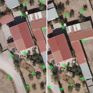
Digital photogrammetry is the art of using computers to obtain the measurements of objects in a photograph. It typically involves analyzing one or more existing photographs or videos with photogrammetric software to determine spatial relationships. Used to create topographical maps, it may also be useful in a variety of industries. Naksha Tech’s team of Photogrammettrist create quality Vector data and ortho-photos with assured spatial accuracies. To achieve completeness and accuracy of each project, Naksha tech uses specific quality control and quality assurance team to meet client needs. They make sure their outputs are done right with an extensive quality control methodology. We provide the following photogrammetric offering to meet our clients’ needs.Aerial triangulation DTM/DEM Digital Orthophotography Large scale and small Scale mapping 3D city Modeling Digital Orthophotography: An orthophotograph is an aerial color photograph geometrically and geographically corrected to be superimposed on a plan. The production of orthophotograph consists of correcting the distortions of the exposures caused by ground surface relief. Digital Orthophoto are used as maps, for visual identification and also with combination of other mapping products like DTM and contours. We generate digital Orthophoto that most closely achieves the resolution of the continuous tone and original aerial image. We apply a variety of image enhancement and edge sharpening routines using special Image processing techniques. The process involves colour / contrast matching and feathering techniques to ensure a virtually seamless mosaic. Many images can be mosaic ked and re-sampled to produce an overview image file to supplement the original orthoimages. Accuracy is measured by comparing the rectified position of ground control point to the true coordinates of the point. We create Orthophoto with different pixel sizes. We work on RGB and Four band imagery which includes; Orthophoto generation / Ortho rectification, Seam line Editing, Color Balancing, Creating Mosaics, Edge Matching. Digital Photogrammetry Products: DTM Ortho Photos Ortho photos Seam Line 3 Dimensional Maps Contours
Looking for Digital Photogrammetry Services Providers

Digital Photogrammetry
Get Price Quote
• Aerial Triangulation • DEM DTM Generation • Stereo Compilation • Topographic and Planimetric Feature Extraction (2D and 3D) • Vector Mapping (1:1000,1:5000, 1:10,000 and 1:50,000 Mapping scales) • Ortho Photo Generation and True Ortho Generation • Ortho Mosaicking And Tile Generation • Contour Generation • 3D Terrain Visualization • 3D City Modeling using Mono Stereo Images

Digital Photogrammetry service
Get Price Quote
Midwest infotech’s state-of-art digital photogrammetry services offer superior quality expertise in delivering latest technological solutions in digital photogrammetry using erdas imagine.

digital photogrammetry services
Get Price Quote
digital photogrammetry services, GIS Survey Services, Lidar Data Processing

Digital Photogrammetry
Get Price Quote
Digital Photogrammetry, LIDAR Mapping

Digital Photogrammetry & Imaging
Get Price Quote
Digital Photogrammetry & Imaging, Geospatial Fusion Solutions

Digital Photogrammetry and Image Services
Get Price Quote
Digital Photogrammetry and Image Services, V Shaped Modular Kitchen

Digital Photogrammetry Digital Photogrammetry
Get Price Quote
Digital Photogrammetry Digital Photogrammetry, GIS / AM / FM, remote sensing

digital photogrammetry services
Get Price Quote
digital photogrammetry services, GIS & Digital Cartography

digital photogrammetry services
Get Price Quote
digital photogrammetry services

digital photogrammetry services
Get Price Quote
digital photogrammetry services, Lidar Data Processing, Web GIS Services

digital photogrammetry services
Get Price Quote
digital photogrammetry services

photogrammetry process
Get Price Quote
photogrammetry process, Gis mapping software, 2D & 3D mapping, cad softwares

Digital Photogrammetry
Get Price Quote
Digital Photogrammetry

digital photogrammetry services
Get Price Quote
digital photogrammetry services, lidar services

Digital Photogrammetry
Get Price Quote
Digital Photogrammetry, Contour Mapping, COGO, Digital Mapping

Digital Photogrammetry
Get Price Quote
Digital Photogrammetry, Parcel Map Conversion, gis consulting services