topographical land survey
Get Price Quote
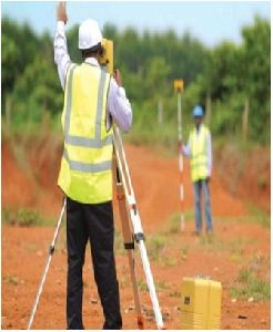
SURVEY TOPOGRAPHIC : Alignment Survey for Transport Corridors, Utility Corridors, Canals, Oil, Gas, and Water Pipe Corridors. River Basin, Catchments, Industrial,Commercial and Urban Zones. PLAIN TABLE AND CONTOUR : Housing, Industrial, Transport, Irrigation & Water Resources. GIS : Geographical Information System Using Satellite Imagery, DGPS, GPS. MARINE SURVEY : Water Depth Evaluation, River / Nalla / Water Body Profiles. FIELD STUDIES CADASTRAL SURVEY : For Land Use / Size and Ownership Details. Demographic Survey. CONSTRUCTION MATERIAL SURVEY : For Housing, Commercial, Industrial Projects. ANALYSIS & SPECIAL REPORTS : Generation of 3D Digital Terrain Maps, Digital Contour Maps, Earthwork Estimation Schedules (Based On 3D), Transport Corridor Geometrical (Horizontal & Vertical) Designs, Satellite Maps. Projects executedTownships, Special Economic Zone. Irrigation Projects, Road, Highway & Bridge Projects, Industrial Projects, Route Alignment for Various Utilities.